From http://news.mongabay.com/2009/1130-indigenous_mapping.html
Rhett A. Butler, mongabay.com
November 29, 2009
A new handbook lays out the methodology for cultural mapping, providing
indigenous groups with a powerful tool for defending their land and
culture, while enabling them to benefit from some 21st century
advancements. Cultural mapping may also facilitate indigenous efforts
to win recognition and compensation under a proposed scheme to mitigate
climate change through forest conservation. The scheme—known as REDD
for reducing emissions from deforestation and degradation—will be a
central topic of discussion at next month’s climate talks in
Copenhagen, but concerns remain that it could fail to deliver benefits
to forest dwellers.
Much of the Amazon rainforest remains occupied by tribal
groups. While few of these live as conjured in the imagination, the
state of the forests in their territories is a testament to their
approach to managing lands. But like the Amazon itself, these groups
face new pressures from the outside world. For the indigenous, the lure
of urban culture is strong—cities seem to offer the promise of
affluence and the conveniences of an easy life. But in leaving their
forest homes indigenous peoples are usually met with a stark reality:
the skills that serve them so well in the forest don’t translate well
to an urban setting. The odds are stacked against them; they arrive
near the bottom of the social ladder, often not proficient in the
language and customs of city dwellers. The lucky ones may find work in
factories or as day laborers and security guards, but many eventually
return to the countryside. Some re-integrate into their villages,
others return in a completely different capacity than when they
departed. They may join the ranks of miners and loggers who trespass on
indigenous lands, ferreting out deals that pit members of the same
tribe against each other in order to exploit the resources they
steward. As tribes are fragmented, and forests fall, indigenous
culture—and the profound knowledge contained within—is lost. The world
is left a poorer place, culturally and biologically.
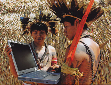 In Rondonia, Brazil, Surui use ACT-provided laptops to monitor their reserve using Google Earth technology. Photo © Fernando Bizerra Jr. |
But there is new hope, embodied by efforts to enable
tribes to become more self-reliant through the use of state-of-the-art
technology that builds on and leverages their traditional knowledge.
These tools can help them better defend their lands and offer the
potential for the next generation of Surui, Trio, or Ikpeng to have a
future of their determination rather than one dictated to them by a
society that values the resources locked in their territories over
their forest knowledge and rich cultural history. Through such
technology, tribes may be able to avoid a fate in which they become
destroyers, rather than protectors, of the basis of their culture—their
forest home.
At the forefront of this effort is the Amazon Conservation
Team (ACT), a Virginia-based group with field offices in Brazil,
Suriname, and Colombia. the Amazon Conservation Team has pioneered
geographic information system (GIS) training of indigenous groups in
the Amazon to enable them to map their land, not only as a means to
demarcate it and win title, but to catalog their cultural links to the
land. In building these “cultural maps,” tribes construct maps of their
territory that go beyond the topography of the terrain, capturing the
underlying richness of generations of human experience, including their
interaction with the land and other tribes, and the distribution of
plants and animals of nutritional, medicinal, and spiritual
significance. In other words, in as much as indigenous culture is a
product of the land, the maps capture the essence of these tribes.
But creating a cultural map is no easy task. It can take years
of work by the tribe, laying out what the map will contain, determining
what communities will participate, and coordinating who in the
community will do the actual footwork. Other considerations also come
into play, including harvesting cycles and seasons—mapping can’t
interfere with the ongoing the activities that sustain the tribe—and
the treatment of intellectual property contained in the maps, since
these can be used for nefarious purposes in the wrong hands, including
exploitation of timber, game, and medicinal plants.
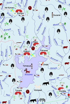 A model map created by Indians in Brazil. Image courtesy of ACT. |
The training itself can also be complex. Indigenous
mappers must learn the ins and outs of handheld GPS units, GIS systems,
computers, and Internet tools like Google Earth before they can
construct maps and monitor their territories for threats and
encroachment. But the payoff can be well worth the effort: 20 groups in
the Brazilian Amazon have created culture and land use maps of their
territories. The maps include 7,500 indigenous names, 120 villages, and
thousands of area of cultural and historical significance. In Suriname,
the maps are being used to help indigenous groups get government
recognition of—and eventually title to—their lands. Some of the
indigenous mappers have gone on to become certified as park guards,
enabling them to earn an income while working to safeguard their lands.
The new handbook, “Methodology of Collaborative Cultural
Mapping,” walks readers through the process of establishing community
meetings between stakeholders, composing the mapping team, setting up
training workshops, conducting fieldwork, developing the map, and
finally delivering the map. The guide, which is available in both
English and Brazilian Portuguese, comes at an opportune time: interest
in tropical forest conservation has never been higher. The reason?
Tropical forests are seen as critical in combating climate change, both
in terms of their value in sequestering carbon and as a political
compromise that could serve as the developing world’s contribution to
reducing greenhouse gas emissions. As long-time stewards of tropical
forests, indigenous people are effectively forest carbon guardians. But
questions remain as to whether they will be recognized as such. Mapping
their lands may help indigenous groups demonstrate their critical role
in forest conservation efforts, earning them recognition, compensation,
and a stronger voice in determining how their resources are managed.
An example can be found in the Surui tribe’s carbon project in
Rondônia, Brazil, which aims to protect 250,000 hectares of forest.
Prior to establishing the carbon project , the Surui worked closely
with the Amazon Conservation Team to develop a cultural map of their
lands.
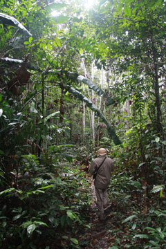 Indigenous park guards on patrol near Kwamalasamutu, Suriname. |
“The Surui ethno-graphic (cultural)
map has become the key instrument in integrating their traditional
knowledge of the forest with the latest technologies in carbon
measuring and monitoring,” Vasco van Roosmalen, director of the Amazon
Conservation Team-Brazil, told mongabay.com. “It is one of the key
instruments in translating the necessities of a carbon project to the
community and in ensuring that their perspectives are truly integrated
into the project design.”
Mark Plotkin, president of the Amazon Conservation Team, adds
that having completed their map, the Surui are much better positioned
to move ahead on their carbon credit project.
“After the mapping process has been completed, some of the
indigenous are trained as internationally accredited park
guards—meaning the forest protectors are in place, which is a real
hurdle for other carbon projects where nobody lives in and protects
these forests,” he told mongabay.com.
“Ethnographic mapping represents the perfect marriage of
ancient shamanic wisdom and 21st century technology,” Plotkin
continued. “When done right, it results in better protection of the
rainforest and enhanced capacity of the Indians to meet the
opportunities and challenges posed by the outside world.”