Now that you have finished the digitizing process, you will want to perform some quality checks on your efforts. Due to the repetitive nature of the process, even the best mappers can make mistakes. Ideally, quality checks should be performed during the digitizing process, as you analyze all the information that you’re creating. Quality assurance means double checking to make sure that the information makes sense and is useful.
Spatial Location: Overlay the UOM data on your base maps (either vector or raster). Does it make sense? Are there excessive errors? For example, is a canoe route overland where it’s not supposed to be? Did you miss any features?
Incorrect codes: are there any codes that are missing? Have you entered codes incorrectly? This can be harder to catch, but I suggest performing random spot checks of the digitized data and the georeferenced map, as well as looking at the attribute table to make sure there aren’t missing categories/themes.
If you have entered the codes without using the domains, it is possible that some number of codes input during the digitizing process will be incorrect due to human error. You can catch these inconsistencies after joining the code categories to the attribute tables. Each code that doesn’t match up with codes in the ‘key field’ will have to be manually corrected.
Tutorial: Quality assurance of your completed datasets
1. Right-click on the layer you wish to QA and select Properties.
2. Click the Labels tab.
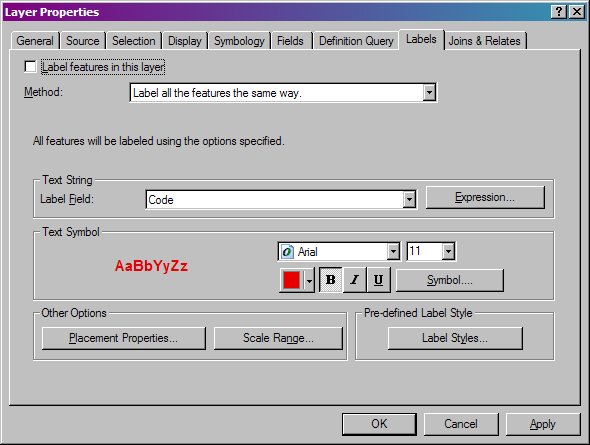
3. Check the box that says Label features in this layer.
4. Choose the correct field (Code).
5. Modify the font as necessary.
6. Click OK.
7. Methodically review the map sheet for missing or incorrect codes.
Note: codes may not appear if you are zoomed out.