Original Story Here
Part of the Digital Places Special News Series
More Digital Places Stories>>
Isolated tribes in the Amazon are now using satellites, computers, and even Google Earth to guard against threats from logging, agriculture, drug wars, and oil operations.
Many Indian groups have struggled to protect their lands—which often contain oil reserves or high-value timber—because they have no official records of the borders of tribal territories.
So activists have been training these South American communities to use digital mapping technologies such as geographic information systems (GIS) to build maps that definitively outline their properties.
Jen Osha is co-founder of the nonprofit group Aurora Lights and a doctoral student in geography at West Virginia University.
Osha said that participatory GIS—the blending of local geographic knowledge with modern mapping data—can help indigenous communities stop the loss of ancestral lands and decrease Indian’s reliance on foreigners.
"The process of making maps can increase community organization and empower community members in daily relationships with [government] officials, because they now have hard data they can use," Osha said.
Shifting Strategies
In eastern Ecuador the Huaorani (wow-rah-nee) people are under increasing pressure to surrender their land to logging and international oil companies.
(Related photos: effects of logging in the Amazon Basin.)
One Huaorani family had been leading its tribe deeper into the forest to retreat from encroaching developers, Osha said. But digital mapping showed the group the need to shift their strategy.
"When they developed a map, they understood that they were surrounded on three sides and had nowhere to go," she said. "They had to choose a new tool. Now they have decided to use participatorymapping to defend themselves."
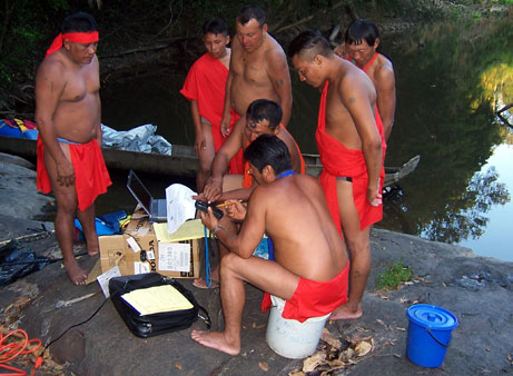
The Huaorani maps were made by community members who went on foot surveys carrying global positioning system (GPS) receivers. The GPS data was combined with tribal knowledge of the rain forest as well as mapping data from Ecuador’s Geographic Military Institute.
The tribes "are using the maps for a number of things, like defining areas for hunting, tourism, and conservation," said Jascivan Carvalho of TROPICO, an eco-tourism company that has worked with the Huaorani.
An official at the Geographic Military Institute said that eco-tourism groups were the primary users of the agency’s data. But he confirmed that a growing number of local communities are leveraging the institute’s resources for use in negotiations with petroleum companies.
Osha adds that some communities are also using the maps to seek mineral rights from the government.
The U.S. Agency for International Development (USAID) is another group that has supported digital mapping projects in Ecuador.
Monica Zuquilanda, a locally hired USAID project manager, said the agency has contributed to GIS programs that help indigenous groups "to identify the boundaries of their ancestral territories, plan forest management, resolve territorial conflicts, and to establish legal rights to their territory."
In an email, Zuquilanda said that the agency has helped train guadaparques—tribal members tasked with guarding indigenous territories—to use GIS and GPS.
In one case, she said, the guards located an illegal coca-growing operation in their lands that was eventually shut down.
Generational Bridge
The Amazon Conservation Team (ACT), a conservation group working in lowland tropical South America, is one of a number of teams helping with geospatial strategies in Suriname, Colombia, and Brazil.
For one project the group has partnered with the Brazilian government and 18 tribes to create maps covering millions of acres.
Illegal mining and logging operations are an intractable problem in the region, activists say.
The maps are "an effective way of locating and identifying these illegal operations," said ACT co-founder Mark J. Plotkin.
ACT also helps indigenous groups use the Google Earth virtual-globe program to get a satellite’s view of their territory. The non-profit often trains younger, technology-hungry members of native communities to perform the digital searches.
In particular, clandestine airstrips and riverside mining operations can be impossible to spot from the ground. So when Google updates its high-resolution imagery, scouts pour through the maps for evidence of new mines, such as river discoloration caused by sedimentation and pollution.
(Related news: "Satellite-Photo Atlas Uses Digital Globe to Show Eco Damage" [October 23, 2006].)
What’s more, Plotkin said, the mapping technologies are bridging generational gaps.
"One of the most important positive aspects is that the technology connects generations," he said.
"Grandpa might be naked and painted red and junior might want an iPod, but the [mapping] technology gives the younger generations a newfound appreciation for the ancient [ways]."
Free Email News Updates
Best Online Newsletter, 2006 Codie Awards
Sign up for our Inside National Geographic newsletter. Every two weeks we’ll send you our top stories and pictures (see sample).