25-8-2006 / All Information and Data Available in Standardized For mats
Web-based Information Service Canada
Together with provincial and territorial government and other partners the federal government’s Agriculture and Agri-food department has announced the development of an Internet-based National Land and Water Information Service. With federal government funding of CDN$100.1 million, the service will provide geospatial information and tools to assist in agri-environmental decision-making across the country.
By Ronald Baynes
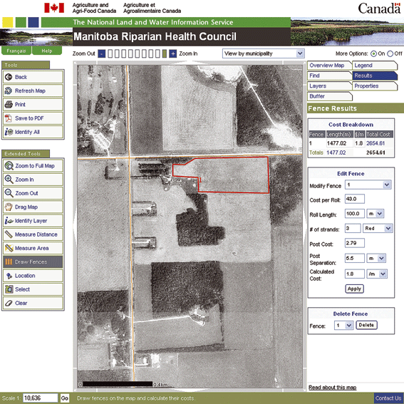
An example of the web mapping services that the National Land and Water Information Service will provide is an interactive ‘fence locator’ that Agriculture and Agri-Food Canada (AAFC) developed in collaboration with the Manitoba Riparian Council. Landowners use it to come up with rapid, precise estimates about costs and locations of fences to keep their cattle clear of waterways or to section off areas of land for rotational grazing. Ron Lewis, AAFC’s Agricultural Information Manager in Manitoba says: “The application displays an orthophoto map of the land, complete with waterways and trees. The user sketches in proposed location options for the fence and receives an automatic readout of how many metres each will take. The application then cues the landowner to enter such variables as distance between fence poles, the number of wire strands and how much the user will pay for a roll of wire. Other spatial information is available that enables the landowner to place the fence far enough from the waterway to comply with environmental guidelines or regulations.”
Canada-wide Collaboration
The Internet-based National Land and Water Information Service supports a Canada-wide strategy called the Agricultural Policy Framework. Under this framework federal, provincial and territorial governments are working together to make Canada a world leader in food safety, innovation and environmentally responsible agriculture. Green components of the strategy include environmental farm planning, farm stewardship, water supply expansion and water quality surveillance. Decision makers who hitherto have had to patch together soil, water and other agri-environmental data from a multitude of sources will now be able to access it in standardized formats through a single, recognized Internet portal. The site will provide direct access to information, tools and advice from experts and will eventually incorporate links to the collaborating organizations. All information and data will be available in standardized formats and in Canada’s two official languages English and French.
 Some tools and applications are already available on www.agr.gc.ca/nlwis, the interactive portal to the National Land and Water Information Service. |
First Phases
The National Land and Water Information Service is being implemented in four overlapping phases from 2005 to 2009. In Phase 1, which began in May 2005, the project team consolidated Agriculture and Agri-food Canada’s existing GIS capabilities and introduced the Land Resource Viewer (LRV). This web mapping application puts geospatial information into a context appropriate to the user’s interest, for instance a watershed context for a user whose interest centers on watersheds. The first release of the LRV provides a national agricultural view so that users can see the Canada-wide context for their area of interest. In Phase 2, also under way, the team will build the Information Technology infrastructure for the data maintenance portion of the service, including GIS-based data warehouse, and associated tools and applications. In this phase, the National Land and Water Information Service will use commercial off-the-shelf technology including ‘thin client’ computer systems, to consolidate distributed data bases into a single integrated environment. “In this phase we will be using primarily the same technologies we have been using previously,” says Assistant Deputy Minister Susan Till who heads the service. “However we will use them in more effective ways that will allow us to better share and manage data.”
Phases 3 and 4
In Phase 3 the service will make customized applications available on the website introducing new web services on a nationwide scale. The Canada Parcel Locator, a land-use application, which AAFC currently provides in the Prairie Provinces, is an example of a web service that will be expanded to cover more agricultural areas of Canada. The Locator allows users to zero in on geospatial, web-mapped renditions of data and information on specific parcels of land and spatially enable tabular data. Information will be delivered using formats that are consistent with national standards and policies defined by the Canadian Geospatial Data Infrastructure (CGDI). The CGDI has been developed under GeoConnections, a national program funded by the federal government. In Phase 4, data access and linkages between collaborators will be enhanced and a new, capability-rich suite of products will be introduced. Till: “By the end of Phase 4 users will have access to information and interpretation capabilities currently available only to organizations that own their own sophisticated GIS systems. One advantage of this phased approach is that applications will come into use as they are developed. We won’t need to wait five years to see results.”
Three Modes
The Service will be available in three modes. Self service allows clients to use the site’s help menu to access information free of charge, including information on how to search and navigate the website. Assisted service takes place through tutorials or technical backup from a service office now under development. Custom service are applications or interpretations individually tailored to meet clients’ needs created in collaboration with experts from the National Land and Water Information Service. With its inherent emphasis on sharing and consistency of data, the service depends for its success on a close dovetailing of effort by many partners and collaborators. These include Canada’s federal, provincial, territorial and municipal governments, agricultural producers and industries, NGOs and academic institutions. Provincial Working Groups are helping to identify applications. The National Land and Water Information Service has signed several agreements to access data from provincial and federal departments and agencies and is in the process of negotiating with others. “Response so far has been enthusiastic and we have heard from many people who want to work with us”, says Till. “We are off to a good start.”
Ronald Baynes ( baynesco@magma.ca ) is a free-lance writer based in Ottawa.
More information about the topic discussed in this article can be found at www.agr.gc.ca/nlwis-snite