The emergence of online data sources for satellite imagery have been more prevalent in the past year. Three websites that come to mind are ResMap, University of Maryland Global Land Cover Facility and GeoBase. ResMap.com links the user to various types of satellite images without the need to download the data. Whereas, the Global Land Cover Facility allows the user to download the images directly to their computer. While GeoBase is a website run by the federal government of Canada.
What is ResMap?
ResMap provides free online access to GIS-ready satellite data. Imagery covering the entire globe is accessible, with resolutions ranging from 1 km to 14.25 metres for most areas, and in some selected regions 1 metre imagery is available. Over 4 Terabytes of LANDSAT imagery is available for direct and free use in GIS/CAD/RS/MS Office applications on your desktop without the need to download the data.
Established as a subsidiary company of the Spatial Mapping Ltd., ResMap depends on the depth of its parent company to help fufill the GIS/RS and Database development needs of it’s clients. ResMap images are directly accessible at no charge from a variety of popular GIS, Remote Sensing, Mapping, CAD and MS Office applications.
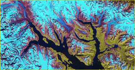 Satellite image courtesy of ResMap.com |
Some frequently asked questions
What the system does:
ResMap allows access to GIS-Ready satellite imagery via an Image Web Server. System users conveniently reference and utilize the satellite maps they need free, online, and real-time.
Who uses ResMap:
Resource management professionals, scientific community, educational institutions, media outlets,and many others rely on ResMap. Really, anyone who needs rapid access to spatially correct imagery will find this system useful.
Why ResMap is useful:
Our process makes it easy to access the data you need, without needing to warehouse endless terabytes of data. ResMap images can be used directly in your existing GIS/CAD/MS Office software. Instructions on how to do this are here.
Primary data sets:
You can look to ResMap to supply all the standard map sets you require. From MODIS to Landsat to air photo data, rely on ResMap. Regions covered by ResMap: Imagery covering the entire Earth is accessible on ResMap at resolutions ranging from 1 km to 14.25 metres, and in selected areas 1 metre.
Free Images:
ResMap allows users free access to imagery covering 100% of the world’s landmass with more being added weekly. Click on the Search button to see imagery covering your area of interest.
Offline Images:
All the imagery served via ResMap is available for purchase at deeply discounted rates.
What is the Global Land Cover Facility?
The Global Land Cover Facility (GLCF) develops and distributes remotely sensed satellite data and products. They are concerned with land dynamics from the local to global scales. GLCF is a funded member of NASA’s Earth Science Information Partnership.
As you explore their web site, please take advantage of their free data and products. These may be accessed electronically through the Earth Science Data Interface (ESDI). The Earth Science Data Interface is the GLCF’s web application for searching, browsing, and downloading data from their online holdings, utilizing three methods of searching: a Map search, a Path/Row search, and a Product search.
If you are unsure whether GLCF data, products and services can be of assistance to you, you may find it helpful to know that the majority of their users (certainly not all) come from the following communities:
- Science Example: geography, Earth science, ecology, climatology
- Environmental Policy Example: global warming, sustainable development, risk management
- Resource Management Example: biodiversity conservation, forestry, protected area management, forest inventory
- Disaster Management Example: fire, flood and drought monitoring, disaster mitigation, food security
- Computer Science Example: Data mining, data fusion, computer vision
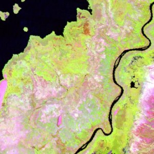 Satellite image courtesy of the GLCF website |
Some frequently asked questions
What data does GLCF have?
Top GLCF currently holds more than eight terabytes of raw and derived remote sensing products. Their composite holdings are listed at http://glcf.umd.edu/data/.
Am new to remote sensing and GIS. What can I use this data for?
The data provided by GLCF can prove useful in global, regional and even local analyses of the earth’s surface. Many of their derived products, such as their 1km global land cover product can be particularly useful when combined with higher resolution data types such as Landsat TM, ETM+ and MSS.
Do I have to pay for the data I find on the web site?
Not currently. The GLCF has taken extraordinary measures to ensure that users of the data are not charged when they download from the web site. If individuals require media duplication, they request a $25 + shipping fee per item ordered for the cost of media, postage and labor.
For more information, please visit the GLCF website at http://glcf.umd.edu/data/landsat/