(Content of this story courtesy of The Borneo Project. To view complete stories follow this link to the review of the court case and ban on community mapping)
Hot on the heels of a landmark court victory, where a village map was the key piece of evidence used to prove customary rights of the Rumah Nor over rivers, streams and customary forests, the Malaysian government passed a law that makes community mapping illegal.
 |
The new law is “designed to undermine community-based mapping and prevent villagers from defining and defending their land rights in the courts. This new law, the Land Surveyor’s Bill 2001, now requires that all map makers be certified by the Director of Lands and Surveys–a politically appointed position. Mappers without certification face steep fines and up to three years imprisonment if caught mapping without permits.”
This ridiculous story was brought to our attention by Harlan Thompson from The Borneo Project who emailed us after finding the Aboriginal Mapping Network while looking for resources on Canadian Aboriginal law. Since Canada and Malaysia are both British Commonwealth countries legal cases in one country can be used in another.

Hopefully lawyers here in B.C. are aware of this Malaysian where the Iban village of Rumah Nor on the island of Borneo in Sarawak, Malaysia proved that the Borneo Paper and Pulp company did not have the right to destroy Rumah Nor’s rainforest.
After two years of litigation, the court upheld the customary rights of the Iban village Rumah Nor, finding the Borneo Paper and Pulp company (BPP) did not have the right to destroy Rumah Nor’s rainforest. This decision – which in no uncertain terms expands the definition of customary lands to include rivers, streams and communal forests – sets a significant precedent for native villagers seeking land rights in Malaysia. Prior to the ruling, only farmlands actively cultivated by forest dependent communities could be considered native customary lands.
If upheld, the ruling could have broad implications for native land rights struggles around the world. Since legal precedents from British Commonwealth countries such Malaysia can be used in other Commonwealth countries, this case could be used to protect First Nations’ lands in Canada or Aboriginal lands in Australia.
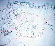
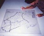
The ruling would never have come about without years of hard work by local non-governmental organizations (NGO’s) who have organized local communities and helped them understand and defend their legal rights. Rumah Nor was assisted by the Borneo Resources Institute (BRIMAS) and a legal team headed by lead council Baru Bian. A crucial piece of evidence in the case was a village map created by BRIMAS mapper Samy Anak Ising. Samy was cross examined for three days in the court room. In the end, High Court Judge Datuk Ian Chin Hon Chong ruled that while the defendants “demanded perfection” from the map, “such perfection was not necessary in proving who owned the land.” He added that, “the map he produced is as accurate as it can possibly be given the equipment he has.”
The importance of the map in the judge’s ruling is vindication for The Borneo Project’s mapping program. Over the past seven years, The Borneo Project has trained dozens of local mappers who have helped more than 50 villages map their lands. Samy Ising was one of many trained by Borneo Project volunteers.
“This court ruling raises the stakes for community mapping.“
This court ruling raises the stakes for community mapping. Currently over 20 native land cases are working their way through the Sarawak courts and the need for additional maps to prove native land rights in court has never been greater.”
Recognizing the power of the maps in courts, the Malaysian government stepped in and passed a law which effectively makes this type of community mapping illegal.
When questioned by the media on this law, Meena Raman, Executive Director of the non-governmental organization (NGO) Sahabat Alam Malaysia (SAM), stated: “this law is shocking and will definitely have serious repercussions on our mapping work. The crucial parts are the limitation on cadastral surveys of land and the penalties for the ‘offense’ of ‘practicing illegally as a surveyor’. These provisions are a reaction to the Rumah Nor victory and are attempts to defeat the right of indigenous people to determine their boundaries.“
“…closer examination of the wording shows that the law has a devastating impact against the natives’ ability to defend their land.“
Jok Jau Evong, also from SAM and winner of the 1998 Conde Nast Environmentalist of the Year Award, further explained that, “at first glance, the law appears to be a reasonable set of rules regulating the surveying profession, since it creates a Land Surveyors Board to regulate the activities of land surveyors. However, closer examination of the wording shows that the law has a devastating impact against the natives’ ability to defend their land.“
The one consolation about the new law is that it shows how effective community mapping has been. There was no community mapping in Sarawak at all when the Borneo Project began training mappers seven years ago. Since then, several local NGO’s, including SAM, IDEAL and the Borneo Resources Institute (BRIMAS), have mapped dozens of villages with experienced local mappers trained by the Borneo Project. In the wake of the Rumah Nor case, other NGO’s in Borneo have expressed great interest in developing mapping programs. Dozens of new lawsuits against logging and plantation companies are in the works, and all of them need maps showing community boundaries and the areas trespassed by companies.
Since the sudden passage of this law, Sarawak NGO’s have grappled with how to respond. There was no opportunity to oppose the legislation, because the ruling government party controls nearly all seats in Sarawak’s state legislature. In fact, this particular law swept through the legislature without debate on the first day of the new legislative session–a mere three days after being publicly announced.
Sarawak’s NGO’s all agree that mapping work should not stop. Their lawyers are optimistic that this law can be challenged and eventually overturned, though it will be a long and costly process. For instance, according to the new law, every map made by certified mappers must be approved by the Director of Lands and Surveys before it can be used in the courts. Thus, the law may be unconstitutional by usurping the power of judges to determine whether community maps will be permissible as evidence or not.
In the meantime, community mapping proceeds as usual, but with several specific new approaches. First, more maps need to be made by the people living in villages under threat, and fewer by outside mappers from local NGO’s. This means that many more villagers will have to be trained in advanced mapping skills.
A second approach is to help experienced community mappers gain official certification. This will require additional training and course work in surveying. We will then see if the government arbitrarily precludes community activists from gaining certification. A third option is to hire licensed surveyors. This would require additional funds and it may also be difficult to find licensed surveyors who are willing to risk their professional reputation for the politically unpopular cause of native land rights.
Thanks to Harlan for bringing this story to the AMN’s attention. It is a sobering reminder of how instrumental maps can be in influencing court decisions and in turn, the fate of our resources. First Nations in B.C. can no doubt empathise with the struggles of the Rumah Nor to find ways to protect, manage and benefit from the use of the resources in their territory.
For a more information on The Borneo Project and for the stories quoted above follow the links. Harlan also wondered about forging better links between First Nations here in B.C. and Malaysia. Any ideas?