Summarised from A Survey of First Nations Geographic Information Systems Hardware and Software produced under Canada-BC Information Sharing Protocol, Federal Treaty Negotiation Office, and BC Treaty Negotiation Office
A survey of First Nations organisations has found that most organisations have GIS capabilities, or have mapping done by external agencies. ESRI software packages were found to be the most common software used. The survey also found that GIS is being used for a wide variety of tasks including resource management and mapping of Traditional Use Studies and Land Claims.
The survey, conducted by the Canada-BC Information Sharing Protocol, looked at the level of use and interest in GIS among First Nation organizations. A total of 109 First Nation organisations participated in the survey representing individual First Nations, Bands, Tribal Councils or other Affiliations. The objectives of the study were to determine the level of use and interest in GIS among First Nation organisations; facilitate information sharing between First Nations; allow First Nations to become strategic when developing a GIS information management system; allow First Nations to capitalize on each other’s successes, knowledge and advice; and bring forth a common technical standard for storing land and resource information.
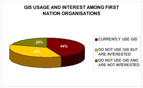
Of the organisations surveyed 44% currently use GIS while 36% are interested in acquiring GIS software some time in the future. Twenty-two organisations surveyed have no interest in developing GIS in the foreseeable future. Lack of funding, insufficient need (ie. GIS support is currently provided from outside), difficulty with implementing infrastructure, and trouble in finding adequate personnel are the predominant reasons for not implementing a GIS operation.
Nine of the twenty-two offices without GIS software had had GIS software in the past. Lack of funding, problems maintaining personnel, insufficient work, and consolidating GIS operations lead to the demise of GIS in these offices. Five of these offices are interested in resuming GIS operations while the others are not at all interested.
One of the biggest obstacles for those who currently have, or are interested in establishing, a GIS office is the cost. Both start-up costs and the cost of maintaining on-going operations present a challenge for users. Outside of the Lower Mainland, training is hard to obtain for most users and all users find that the length of time it takes to train workers in GIS is a costly investment. Further obstacles include the difficulty in obtaining usable data, finding and keeping the right personnel, and maintaining sufficient infrastructure within the organization to support GIS operators. In some cases, organisations find that they do not have adequate work to justify the expense of software and operation. Six organisations expressed difficulty in obtaining support for GIS from their community or Chiefs and Councils. Other obstacles include obtaining technical support for old software and hardware, maintaining confidentiality of sensitive information, maintaining data standards, and the logistics of getting equipment delivered to remote locations.
Most organizations were found to have either internal GIS capabilities or had mapping work done by external agencies. ESRI software packages were the most common type of GIS software used by the participants. The uses for this software range from resource management to mapping for Traditional Use Studies and Land Claims.
The majority of those using GIS are using the ESRI products ArcView and ArcInfo. Microstation, Pamap, and AutoCAD are used to a lesser extent. Most of those surveyed (75%) found that their current software adequately meets their needs. Others found that compatibility with other organisations, lack of analysis and modeling capabilities, inadequate ability to handle large data sets, and difficulty in obtaining technical support were problems with their software.
Most organisations were well equipped with peripheral equipment. Almost all have a desk-top printer, and most have a large-format plotter, and a digitizer. Many have or have access to GPS equipment. To back-up their datasets most organisations use CD writers. Less common methods of back-up include ZIP and JAZZ drives and tape back-up systems. Not all organisations back-up their data. Sixty-eight percent of respondents were satisfied with their hardware although most indicated they would like a faster computer.
The most common use of GIS among First Nations surveyed is Traditional Use Studies (TUS). This was followed by use for treaty processes including land selection models and resource management. Other uses include mapping of cultural and archaeological sites as well as education and communication.
Both current users and those without GIS who were interested in obtaining it expressed interest in using it primarily for resource management. Other potential applications included forestry, municipal uses, mapping of archaeological and cultural sites, education and communication, and data management.
Current users expressed interest in more analysis, 3-D modeling capabilities, and mapping to support treaty negotiations. Future endeavours with GIS included creating a consulting business to sell training and products.
The survey found that fourty-three percent of the organisations with internal GIS capabilities may use external consultants to help them during busy times or for work they do not have the internal capacity to undertake.
Insight and Advice These thoughts on implementing a GIS were shared by those surveyed and may be helpful to anyone who is considering starting-up a GIS office.
General
"Make sure that you thoroughly understand the data you are working with."
"Start small i.e. just get some GIS software that will make maps, then further along in the process get the true GIS software to start doing analysis."
"GIS should become integrated with other parts of the community (e.g. health agencies and local businesses)"
"GIS output is not just the maps, it also provides a source of information for other organisations in the community."
Infrastructure and Funding
"A sophisticated infrastructure is needed to support GIS operations."
"You need to build depth in the community to support a GIS installation. Make sure that there is enough support, and that the GIS installation is not just contingent on a few trained people."
"Start small and make sure that you have the resources to maintain operations."
"The biggest obstacle for First Nations in GIS is not a lack of work or not knowing where to go, but being able to obtain the continued support and funding needed to keep GIS running."
Planning
"Plan first and know what it is going to cost."
"Plan carefully to make sure the data you are gathering will do the job, that you are not just throwing money at the problems."
"Start with a long term, well documented plan for GIS implementation. This will help overcome the problems of staff turnover."
"Do a proper user needs analysis prior to purchase to make sure that it will really meet the needs of the community."
"Get someone with 5-10 years experience to do a user needs assessment. Do your homework first!"
"Develop a good knowledge of what GIS is before you start." "Be sure to shop around for hardware and software."
Personnel
"Have a GIS technician help write the interview questions to make sure that candidates have a adequate technical knowledge."
"It is important to have a committed, generalist type person as the GIS department head. This person needs to have skills in project management, proposal writing, staff training, and have an understanding of the political situation the maps will be used in. They also need to be capable of seeing the department through fluctuations in funding and support."
"Find someone really interested in GIS who will stay with it. GIS isn’t for everyone: it can be time consuming and boring."
"For GIS, you need to keep up with constant change and learning. A GIS person needs to be very familiar with software and hardware, and committed to keeping up with technology."
"Before you spend a lot of money to train employees, make sure that they area committed to staying around for the long haul."
Training
"It is very important to get good training."
"You have to understand computer systems and databases before attempting GIS."
"Get training first so you don’t have equipment sitting around for months while you try to find someone to run it."
"Get people trained first, but make sure you have somewhere for them to go."
"Get proper training for band members through either job shadowing or formal schooling."
"You need both introductory hands-on training and more advanced training. People can be scared to try after just a brief training course, and they don’t know how to use the more advanced capabilities of the software."
"Get proper schooling before on-the-job training. Adequate schooling is necessary to be able to handle all the hardware and software problems you will encounter."
"Establish long term, on site, training and mentoring."
"Training/personnel solution: we use a 50/50 split between hiring community members and outside experts. This allows for mentor style teaching."
"Be aware of the learning curve of the software you are considering. Stick with the simpler packages unless you intend to get very intensely into GIS."
"Don’t shy away from technical support fees. They are worth the money, saving you from down time and consultant fees."
Information Sharing
"Get the copyright on material you produce so you have ownership of your information."
"There is too much emphasis on confidentiality and proprietary data."
"There is insufficient sharing of information between bands which leads to duplication of effort. For example, the same area may be mapped three times by three different bands who have a common interest in it."
"Networking is important so that we avoid all stumbling over the same things."
"Instead of each First Nation setting up their own GIS facilities, First Nations should cooperate and combine resources. This is especially true for small Nations who may not have enough GIS work to justify the cost of the hardware and software."
"First Nations should establish a kind of ‘swap meet’ for GIS hardware and software, so that when one Nation upgrades their equipment, they can pass their old stuff onto a Nation that is just starting out."
Standards and Quality
"Establish GIS corporate data standard before you start (i.e. ask for all you data in a specific format and standard)."
"Develop common symbology and mapping standards to ease sharing of information and reduce duplicated efforts."
"Standardise database information to enable sharing of data."
"We need to be on the same mapping system as major licensees and forestry (NADD 83)."
"Be compatible with what the province uses." "Data is only useful if it has high quality."
"Need a high level of security to assure data quality and standards (i.e. make sure people aren’t throwing junk in)"
"Make sure data is valid for statistics assessment and prescriptions." Encouragement "Don’t be scared of GIS, it is fun after you get used to it."
"GIS is an important technology Aboriginal Organisations, and the benefits outweigh the costs."
"GIS will empower Aboriginal Organisations. GIS enables organisations to make well thought out, intelligent decisions."
"GIS is important for self governance as it provides timely access to timely and accurate information."
"GIS is a good way to establish resources, and to force others to recognize that you have lived in your territory a long time."
"GIS will play an important role in how resources are managed."
"GIS is useful once you get it up and running. It is especially good as a visual tool for presentations."
"GIS is a good tool for negotiations and to educate children within the community about water and land issues."
"GIS is a good initiative for land management, and a good tool for preparing for treaties."
"It is critical that First Nations get started in GIS as soon as possible, so that it is well established before the demands on the GIS become to overwhelming."
"It is the First Nations, not the governments who will be able to achieve a viable database of land information."
"Learn the technology, own the technology, and understand and use it to your advantage."
Caution
"GIS is not always the entire answer. You can waste lots of time playing and not getting results. You need solid information and capacity in order to get anything usable out."
"For small bands, it may not be worth keeping people trained and software and hardware updated. It is more cost effective to use contractors."
"GIS is great technology, but it is just a tool and shouldn’t be relied on too heavily especially for predictive models."
"People tend to take GIS information too literally, never questioning the data. If you are producing maps, know your audience."
"Evaluate the expense versus the demand to make sure an investment in GIS would be worthwhile. GIS requires state of the art technology, so you have to keep upgrading which is expensive to maintain."
"GIS is not value neutral, and the GIS way of looking at the world is not always consistent with traditional views."
"You need to understand the error associated with your data and ground truth data before it is used for decision making."