The Gitxsan Model is an ecosystem based plan, which maps where and how any logging or activity may take place on Gitxsan territory. Unlike conventional timber planning which allocates cut blocks primarily according to short-term political and economic criteria, the Gitxsan Model studies first the ecological and cultural requirements for long-term sustainability. This is done through the overall examination of a series of inventory maps for various ecological, biological and cultural indicators.
The Gitxsan have spent years in the field, collecting biological, ecological and cultural inventories, using Geographic Information Systems (GIS) technology to map this information. They have inventoried and mapped particular species and resources that are representative of the whole ecosystem. These included grizzly bear, moose and salmon. In addition, they have inventoried and mapped for such conditions as soil and terrain stability, age and condition of forests (such as old-growth), the health and quality of salmon-bearing waterways, as well as non-timber resources like pine mushrooms and berries.
Inventories and have been conducted also for culturally significant values and areas. For centuries, the Gitxsan have hunted and trapped Pine Marten, Wolverines, Mountain Goat, Black Bear, Grizzly Bear, and Marmots, as well as fished and collected a wide range of plants for food and medicinal purposes. Gitxsan territory is criss-crossed with trails to hunting, gathering, fishing and trapping areas as well as seasonal and permanent camps, village sites and culturally modified trees. Evidence of the Gitxsan occupation and use of their traditional lands is extensive and beginning to be well-documented on maps. Over 400 days of oral testimony on the Gitxsan occupation and use of their territories was provided by Gitxsan people as part of the court battle that led to the Delgamuukw Decision, and is being used by them for their mapping projects.
The inventories transect both horizontal and vertical landscapes -from the soil layer to the top of the forest canopy. Moreover, a goal of the work is to transect time. The Gitxsan plan to use both terrestrial ecosystem mapping (TEM) and predictive ecosystem mapping (PEM) to move different kinds of planning scenarios forwards and backwards in time. The objective is to move far beyond five-year development plans and 60-80 year timber rotation cycles that dominate current Ministry of Forests planning, to a model that more closely resembles how an ecosystem functions. This type of technology is being explored but not used by the B.C. government, which continues to use outdated forest cover maps (which account for no other criteria beyond timber) to make decisions about where and how much to cut.
The Gitxsan Model is a comprehensive examination of the ecosystem, its structure, its function and its components. Based, then, on the overlay of these maps, the plan determines important and sensitive sites, as well as areas suitable for ecologically responsible forest use. To date, a tremendous amount of information has been collected on the structure, composition and function of ecosystems for Eagle Clan territory in the Skeena West area, and the Wolf and Frog Clan territories. These planning areas comprise approximately 1/6 of the Gitxsan territory.
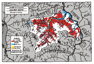
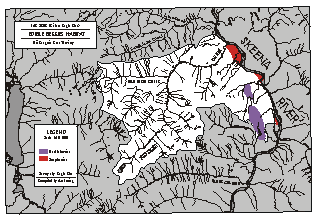
The maps series following show inventory examples specifically for the Eagle Clan territory.

The grizzly bear map shows the range and habitatfor resident grizzly bear. Information was collected through aerialsurveys, forest cover maps, intensive surveys of grizzly bear trails,and strip mapping (a process of walking to transect and recordingdetailed observations of habitat used along the transect.)
The salmon map was compiled through a detailed ground a survey of salmon spawning and rearing areas.
The berries map is based on both detailed ground observation and interpretation of forest cover maps.
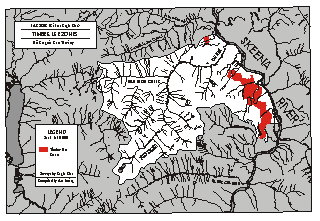
The timber map shows areas were eco- forestry could be practiced on stable terrain without compromising other values.
Thus far the Gitxsan have produced over 50 maps using Geographic Information Systems (GIS to portray the location and extent of indicators species and resources within these two planning areas. The information base from these planning units now includes the remarkable amount of information from soil layers to the top of the forest cavity, combining both Traditional Ecological Knowledge and modern resource uses.