The Grasslands Conservation Council of BC (GCC) is undergoing a detailed grasslands mapping process to arrive at a clear provincial picture of the abundance, distribution and status of BC’s grasslands. The Project team has developed a methodology to accurately map the province’s grasslands at the 1:20 000 scale.
The following is a outline of the steps taken:
1. Ministry of Forests (MOF) Biogeoclimatic Zones at the 1:250 000 scale are being used as an input data source in the development of the base grassland ecosystems layer of the Geographic Information System (GIS).
2. MOF Forest Cover data at the 1:20 000 scale are being used as an input data source in the development of the base grassland ecosystems layer of the GIS.
3. Ministry of Sustainable Resource Management (MSRM) Ecosections data at the 1:250 000 scale are being incorporated into the base grassland ecosystems layer of the GIS.
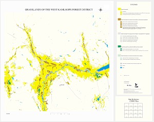
4. 1:20 000 scale base grassland ecosystem layers that have been created are being maintained by Forest District (e.g. Kamloops Forest District grasslands coverage, Lillooet Forest District grasslands coverage, etc.)
5. The Project team has consulted with key agencies and experts to define and select criteria that will assist in the delineation of grasslands in different regions of the province. The Project is using current Ministry of Forests (MOF) and Ministry of Sustainable Resource Management (MSRM) standards for mapping and analysis.
6. Introductory presentations on the GCC and the Mapping Project are being made as the GCC enters into a new region to continue its mapping work. Presentations are made to government officials, non-government organizations, First Nations groups, and other individuals/groups involved with grasslands. Presentations serve to increase Project awareness and to gather local expertise for accurate grasslands mapping in each region.
7. Query and selection criteria are being developed to select out grasslands and grassland associated ecological features from the input data source template* (this is a comprehensive and critical process, and is the foundation for the creation of the base grassland ecosystems layer of the GIS).
8. An Arc/Info Arc Macro Language (AML) has been developed to automate the process of grasslands mapping.
9. Numerous pilot projects are being used to initially test the query and selection criteria (i.e. AML) in different grassland regions of the province. Pilots have been conducted in such areas as: South Okanagan/Similkameen, Kamloops/Lac du Bois, Ashcroft/Hat Creek, Invermere, Premier Lake, Tyaughtun, Churn Creek, Peace River, Kechika Valley, Vancouver Island/Gulf Islands and Anahim Lake.
10. Orthophotos, satellite imagery, air photos, detailed inventories {e.g. Terrestrial Ecosystem Mapping (TEM), Vegetation Resources Inventory (VRI)} and local expertise are being used to help verify the mapping of grassland ecosystems.
11. A local team of experts is established in each region to assist the GCC and its partners in the mapping verification process.
12. Once the “grasslands” selection criteria have proven effective in pilot areas and the resultant mapping has reached a 90-95% confidence level through verification, the Project team will query the input data source template for grasslands and grassland associated ecological features (i.e. “running” the AML).
13. For those areas missed by the AML, the Project team is developing a plan for further assessment using available TEM, VRI, satellite imagery, orthophotos, other detailed spatial inventories and local expertise. Through the use of this supplemental data/information, areas in question will be interrogated to further delineate grassland ecosystems.
14. An AML is being developed in each Forest Region to accurately select out the different grassland ecosystems occurring in the different areas of the province.
15. Regional characterizations for the different grassland types in the province are being developed.
16. The following input data sources are being used in land status overlays** on the base grassland ecosystems coverages:
a. MOF “Ownership” data, delineating private, crown and federal lands
b. Ministry of Water, Land, and Air Protection (MoWALP) Parks and Protected Areas
c. Land Reserve Commission (LRC) Agricultural Land Reserve
d. Lands acquired for wildlife conservation (lands held by The Nature Trust, The Land Conservancy, etc)
e. Surveyor Generals Branch Regional Districts
f. Surveyor Generals Branch Municipal Boundaries
17. Range tenures (including grazing licenses and permits) and grazing leases are being compiled from MOF Forest District offices and the LRC for integration into the GIS.
18. Historical grasslands mapping, representing the third layer of the GIS, will entail three distinct processes to be completed in the following order: 1) the mapping of native grasslands lost to agricultural or urban development within Natural Disturbance Type (NDT) 4 dry valley bottoms 2) the mapping of grasslands encroached upon from the surrounding forest fringe and 3) the mapping of “pocket” grasslands that have disappeared primarily within the Interior Douglas Fir (IDF) Biogeoclimatic Zone.
19. Historical grasslands mapping will require the use of several input data/information sources, namely: Biogeoclimatic Zones; Forest Cover; slope, aspect and elevation data; Bioterrain data; soils data; satellite imagery; orthophotos; old air photos; past historical and forest encroachment/in-growth projects; site descriptions; and local expertise.
20. Noxious weed infestations in spatial form will be compiled from agencies such as MOF, the Ministry of Agriculture, Food, and Fisheries (MAFF), and the LRC. Noxious weed distribution will represent an additional layer of the GIS.
21. Rare and endangered species locations from the Conservation Data Centre will be integrated into the GIS as an additional layer.
22. Other grasslands-related spatial data, such as ATV areas, will be incorporated as additional layers if the Project team deems them worthwhile to include.
23. Formal metadata in line with MSRM standards are being created for each District grasslands coverage.
24. Regular meetings of the Technical Review Committee are being held to review progress, discuss and resolve technical issues, assist in guiding the Project and ensure that the Project produces an accurate and usable product for government and other partners.
25. Deficiencies and gaps in mapping will be documented and recommendations will be developed on how to address these deficiencies.
26. The GIS will be built within the Ministry of Sustainable Resource Management, Kamloops Southern Interior Region Office (built on an Arc/Info GIS-Unix Operating System platform).
27. Formal agreements will be developed both with MSRM and MOF for the development of the Geographic Information System (GIS) database and for access to all required grasslands data and information (these are currently in place).
* Input data source template-Forest Cover/Biogeoclimatic Zone merged data; a ‘union’ of two separate coverages combining the Forest Cover and Biogeoclimatic Zone data in order to select out and query certain combinations of attributes from the two data sources. This is the template from which base grasslands ecosystems are created.
** Land status overlays- the process to create GIS layer 2, a procedure to identify the status of BC’s grasslands (i.e. grassland in ALR, protected area, private land, crown land, Indian Reserve, grazing lease, etc)
|
You can download images of the Grasslands of the West Kamloops Forest District map and its legend below (if you are logged in). For more information on how this map was created, contact Ryan Holmes, Project Coordinator at ryan.holmes@bcgrasslands.org |
The resultant grasslands coverages created are a culmination of the above procedure. The coverages hold a great deal of information in them, and understanding the possibilities inherent in the system can unlock the potential of the data. There are hundreds of queries that can be developed, leading to a number of applications for First Nations. Whether it is determining the distribution of grasslands on Indian Reserves, the historical extent of grasslands in First Nations territories, or the level of threat posed by noxious weeds, the possibilities are endless. Grasslands coverages can also be used in visual or topological overlays with existing First Nations data to better inform land management decisions regarding grasslands.
For more information on the BC Grasslands Mapping Project or the Grasslands Conservation Council of British Columbia (GCC), visit the GCC website at www.bcgrasslands.org or call the GCC in Kamloops at (250) 374 5787.