By Caron Olive, Ph.D. and David Carruthers, M.S.c.
Ecotrust Canada Mapping Office,
202-1226 Hamilton St.
Vancouver, BC V6B 2S8
Please note: this is a draft!
This paper was presented at the Bridging Traditional Ecological Knowledge and Ecosystem Science Conference, Flagstaff, Arizona, August 13-15, 1998.
Abstract
In British Columbia, Canada, community level maps are emerging as a powerful medium to communicate local values and knowledge. The growing momentum of community mapping is largely associated with the on-going legal and planning processes in the province, namely Treaty Negotiations, Traditional Use Studies, and Land and Resource Management Planning (LRMPs). And it is largely First Nations who are leading the way in community mapping within this context. This paper provides three innovative examples from the Ahousaht, Gitxsan and Kwakiutl First Nations, of how maps are being used to put TEK into action. It also discusses some important issues arising from this process. The issues deal with the use of culturally sensitive data in a public planning process, the ability of non-First Nations to interpret the data in a sensitive manner, and the credibility of the data arising from the collection process.
Introduction
Ecotrust Canada is a non-profit organization devising innovative approaches to conservation-based development in the coastal temperate rainforest region of British Columbia, Canada. The Ecotrust Canada Mapping Office was established in Victoria, BC in January of 1996 to provide technical support in mapping and Geographic Information Systems (GIS) to assist in fulfilling this mandate. For the past 2.5 years, the Mapping Office has been working with First Nations and community groups to build local capacity in mapping. The objectives that guide our work are: 1) to improve access to public information resources; 2) to provide training and education in mapping and GIS for environmental analysis; 3) to facilitate the inclusion of local and traditional knowledge into maps and GIS databases; 4) to provide effective mapping products to support and lead conservation advocacy in B.C.; and 5) to strengthen community and regional networks in the use of GIS for conservation-based development.
From our work we have begun to witness the emergence of maps at the community level, as a tool for communicating local values and traditional knowledge. In BC, this growing momentum can be linked to the legal and planning processes ongoing in the province, mainly treaty negotiations, traditional use studies (TUS) and the Land and Resource Management Plans (LRMP’s). We have been watching, and in many cases, supporting this trend in mapping, and as such have gained insights into the motivations, opportunities and barriers in the use of these maps to represent and communicate traditional ecological knowledge (TEK) in these public processes.
This paper provides a discussion of how maps are being used to communicate TEK and local values in British Columbia. This perspective is drawn from our work with First Nations. We are fortunate in that several of the First Nations mapping offices that we have come to know, have permitted us the use of their maps and stories, and have shared their experiences.
We begin this discussion by looking at the cultural climate in BC which is shaping the use of maps in environmental planning. An understanding of this setting is important as it is largely dictating how and why mapping is being used within First Nations communities. As will be discussed in the final section of this paper, this context has given rise to several significant issues associated with using traditional ecological knowledge in public planning processes.
Setting the Stage in BC
Government, industry, First Nations, and communities in BC are all trying to bring certainty to a complex and political landscape. Forest companies want assured access to wood; environmentalists want a 12 per cent protected area status for public lands; the provincial government wants access to revenues and to resolve land-use conflicts; communities want more control over local resources; and First Nations want access and rights over traditional lands. This uncertainty arises with changing social values in how resources are used, and the move towards more sustainable use patterns. The pro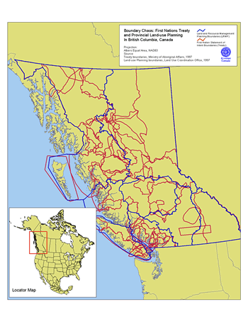 vince is turning to Land and Resource Management Plans (LRMP) in an attempt to begin to resolve this uncertainty. This planning process, however is layered upon an already complex and lengthy Treaty negotiation process. Emerging from these legal and planning processes is what we refer to as Boundary Chaos, as depicted in Figure 1 — uncertainty and often conflicting interests being played out on the BC landscape. What is emerging from this chaos is a growing momentum to use community level mapping as a tool to understand and resolve this quagmire. First Nations in BC are, in many ways, leading this trend.
In BC there are 197 First Nations. No modern treaties were signed, until the historic signing of the Nisga’a treaty in the summer of 1998. In response to increasing pressures to address the long and withstanding issue of aboriginal rights and land title, a treaty negotiation process was initiated by the government in 1993. Employing a six-stage treaty model, tripartite negotiations have been set up between the federal and provincial governments and First Nations. At the table are issues of aboriginal rights, self-government and title to traditional territories. As of June, 1998, 51 First Nations were engaged at a various stages in Treaty negotiations. It has been suggested that title to 110 per cent (due to overlap) of the land base of BC is under dispute.
In the treaty negotiation process, the burden of proof is placed on First Nations to establish their rights to their traditional territory. Traditional Use Studies, or TUS, are the primary tool used to establish these rights. As suggested by the Ministry of Forests, the government agency in charge of directing and funding TUS, the goal of the TUS program is to promote the collecting and mapping of First Nations land use and land use occupancy. This program was initiated by the provincial government, largely to meet its legal obligation in land use management. The main funding source for the TUS program is Forest Renewal BC (FRBC), a Crown Corporation that secures its monies from stumpage fees paid to the province by forest companies. As of July 1997, total government grants to First Nations to conduct TUS have exceeded $5 million (Weinstein 1988).
The TUS program is producing scores of maps of activities on traditional territories. These maps portray knowledge from elders who have lived on the land and have intimate knowledge of their territory. Through collection of oral histories and archival research, they reveal traditional boundaries, traditional and current land occupation, spiritual places, trails and trading routes, camps, traditional resource distribution and variations, as well as resource use over time. These maps are, in reality, the top layer of complex cultural resource systems. They not only provide essential confirmation of aboriginal title to traditional lands, but also act as educational tools for cultural rediscovery.
On December 11, 1997 the Supreme Court of Canada brought down a landmark decision in aboriginal rights. In the early 1980’s the Gitxsan and Wet’suwuet’en First Nations took the BC provincial government to court. This court case was launched as a last resort to force the provincial government of BC to negotiate aboriginal rights and land title with the Gitxsan and Wet’suwet’en First Nations (Skanu’u 1992:vii). The 1991 decision by Chief Justice McEachern concluded that First Nations aboriginal rights had been legally extinguished by the acts of colonial governments in the 19th century. After this loss, the Gitxsan and Wet’suwet’en First Nations appealed the case to the Supreme Court of Canada. The 1997 Delgamuukw decision reversed the 1991 decision, concluding that aboriginal rights have not been extinguished in BC. The ramifications of this decision have not yet been seen on the BC landscape. But, in terms of mapping local values and knowledge, it has placed oral histories on equal footing to written documentation as evidence in the court of law. For First Nations, whose history and culture is recorded through oral histories, songs and dance, the decision is a landmark in aboriginal rights.
The third process driving the mapping trend in BC is the Land and Resource Management Plans, or LRMP’s. This process was initiated to address the "valley by valley" confrontations in BC, such as the 1993 blockades against clear-cutting in Clayoqout Sound. The province established a Commission on Resources and Environment (CORE) to address planning issues on Vancouver Island. After the completion of three regional CORE processes, the province set out to pursue LRMP’s for the remaining areas of the province.
LRMPs are public, regional planning tables, where industry, government, environmentalists, communities and First Nations sit and hash out a plan based on consensus. The LRMPs are being orchestrated by a Provincial Agency called the Land Use Coordination Office (LUCO). At the heart of these regional plans are maps. And the LUCO office is the gatekeeper of the geographic information.
Most of LUCO’s 50 gigabytes of data is science based, such as biogeoclimatic classifications, soils, geology, and forest cover. Don Howes, Program Manager of LUCO recognizes, however, that "local knowledge is an important resource in LRMP and complements formal inventories". As such, they have asked the participants, namely local communities and First Nations to submit maps to the table illustrating local values. Once submitted, it’s LUCO’s job to combine the local with the scientific data in a political context and try to reach agreement in a resource management plan. The next stage is then to implement these plans.
These three legal and planning processes, Treaty negotiations, Traditional Use Studies and the Land and Resource Management Plans, have created a unique environment in BC, one that has demanded the inclusion of traditional knowledge and values into public planning processes. Community level mapping, traditionally initiated in response to internal motivations in communities, is being largely driven by the external pressures of these three processes. Regardless of the motivation, communities in BC are taking on the task in building the capacity to map local knowledge on an unprecedented scale, injecting public planning with values grounded in place. And for First Nations communities, this process is generating visual story boards of oral histories, capturing the rich traditional values and knowledge, often manifested in a range of land use activities. Maps are becoming a powerful medium for bringing traditional knowledge into planning.
Mapping TEK: Taking the Lead
Roman Frank, manager of the Ahousaht First Nations GIS office, has emerged as one of the leaders in aboriginal mapping in BC. Most of his work services the information needs of the Ahousaht Treaty process. His skills, however, combined with advanced GIS technology, are helping to shift the broader balance of power in the community’s relationship with government and industry. Using traditional fonts in the GIS, for example, English place names have been taken off their base maps and replaced by traditional Ahousaht names.
Through oral histories, Roman has begun documenting stories associated with geographic locations on maps. From his work, a rich history of land use is taking shape. For approximately 10km of shoreline, for example, Roman has mapped the location of over 200 traditional place names. What emerges is not a map of "white spaces", often interpreted as "unused lands", but instead a more comprehensive picture indicating a strong historical presence and relationship with the land.
Roman has also worked with Wilcon Wildlife Consulting Ltd to map traditional and scientific data relating to Roosevelt Elk populations and critical habitat in Clayoquot Sound. The maps illustrate data which was collected using transects, tracks and calling and data based on interviews with First Nation elders, hunters and community members. By combining the two types of information, the final report reveals a compelling story in the distribution of the elk, grounded in both science and local experience. The next step, however, may prove to be the most difficult one – using these maps, and others based on a similar methodology, to finalise where logging should or should not take place.
In another part of BC, the Gitxsan Strategic Watershed Analysis Team, or SWAT, has excelled in blending world views and diverse technologies to produce maps and information that are culturally relevant and politically powerful. By integrating data collected from global positioning systems (GPS), ground surveys, oral histories and GIS models, the SWAT team and their colleagues have produced a series of maps of biophysical and cultural values in their territory. These composite maps illustrate, for example, habitat areas for a variety of animal species, such as bear, moose and eagles, as well as food sources, including, huckleberries, salmon berries, and mushrooms. By overlaying the various themes, what emerges is a holistic view of the landscape. These maps are not meant to be bookmarks of a past culture, but instead attempt to bring aspects of past to the present. This information is assessed with ecological, economic and cultural principles to provide an information base for conservation and for developing new sustainable economies.
The SWAT team has been building these valuable baseline databases for the Wilps (clans) that comprise their traditional territory. Other examples of the application of these databases include the evaluation of proposed forestry and resource development plans and to support the reintroduction of traditional management regimes, such as burning for huckleberry and blue-berry management. SWAT is looking to draw from both traditional and scientific ways of knowing to guide resource planning in their territory. According to Darlene Vegh, one of the founders of SWAT, oral histories play a critical role in these baseline databases, helping to map the direction for any research sanctioned by professional ecologists. This approach helps to guide the creation of new management plans, based on traditional practices, such as burning.
In a small community off the north coast of Vancouver Island, Ed Logan is heading up the cultural resource mapping for the Kwakiutl District Council. Their work is fairly unique among First Nations, in that they have completed their TUS inventory, and are now putting it to use. "We receive many fish farm referrals, to renew or approve farm licenses. When we get a proposal, we query our GIS database and make sure there is no conflict with our TUS". Logan told us that he isn’t too worried about submitting this information to the various governments, as it is generalized enough to protect the resources they describe. "We take point data such as clam bed locations and represent it as generalized polygons, without a database". Logan’s approach is a creative response to a larger problem with the TUS process, namely the ability to release cultural information in public processes , while at the same time, safeguarding the information they describe.
Mapping the Transition
The limited examples above describe how maps are being used by First Nations to record and communicate traditional knowledge. In most cases, these maps are being used to respond to planning instead of directing it. This, however, will no doubt change with time in a post-treaty environment. Yet even in this early stage of community mapping development, several issues have arisen in putting these maps to use. As suggested earlier, many of these issues surround the context in which these maps are being produced. Trust is at the centre of all of them. Trust, that the sensitivity of the data will be respected. Trust, that the data won’t be misused. Trust, that the data was collected in a credible way. And trust that the people or agencies interpreting the data have the skills, sensitivity and understanding to do so.
The traditional knowledge placed on maps are often very sensitive data. They may show sacred sites, important food gathering areas, and archeological sites. Conflicts have emerged in the sharing of TUS data. Martin Weinstein, an expert in traditional use methodologies, believes that these conflicts are due to different understandings about TUS information and its role. Weinstein describes in a recent paper that many First Nations are concerned about TUS data being made available to the public through the Freedom of Information And Privacy Act, as public Forest Renewal BC money have funded most TUS initiatives in BC (Weinstein, 1998). This would directly violate any agreements of confidentiality. Weinstein raises the question of trust in this contractual arrangement, where First Nations are trusting the very agencies with which there has been a long record of conflict.
Maps of local knowledge represent an alternative and often divergent view of the world from Western science. We have put a lot of faith in industry and government that local values will be understood. From our experience, there are still many shortcomings in this relationship. And there are very few processes in place to aid in this cross-cultural shortfall.
Russell Collier and Darlene Vegh of SWAT are addressing cross-cultural understanding by working directly in the re-certification of Registered Professional Foresters. They are introducing foresters to the Gitxsan world view, showing them that there is more than one way to manage forests. Overall, the success of SWAT can be attributed to the fact that they are able to stand in both worlds at the same time; gaining trust and respect from the Gitxsan elders and registered professionals.
As most aboriginal mapping offices are set up in response to these external processes, the issue arises as to the necessary internal skill base to produce credible data. The credibility of data becomes significant when maps are scrutinized in the court of law, a system that is more amenable to Western science than traditional knowledge based on oral histories. Even with acceptance of oral histories as legitimate court evidence, as demanded by the Delgamuukw decision, there still needs to be acceptance in the minds of the public and industry.
In a similar vein, the skills to appropriately apply mapping and GIS technology must be developed in each community, or contracted out. In many cases, communities are developing their mapping program in isolation, each office facing similar challenges and barriers as their neighbours. It is in response to this that Ecotrust Canada, in cooperation with the Gitxsan SWAT team and Ahousaht First Nations, created the Aboriginal Mapping Network (www.nativemaps.org). The purpose of this web-based resource is to address common questions and issues associated with mapping and GIS, as well as to provide a forum to share experiences and discuss issues with others in the same field.
Community level mapping is really in its infancy in BC. What we are witnessing is a growing momentum in the use of maps to capture and communicate traditional ecological knowledge. With the right level of trust and understanding, these maps can be used to bridge traditional and scientific knowledge. To some degree, this has begun to happen, but there is still a long way to go. Culturally-based information needs to be shared, but sectors need help in understanding and interpreting this information. Local experiences in mapping need to be shared between communities to create efficiencies and synergies in the development of aboriginal mapping. We need to find innovative ways to safeguard local knowledge in public planning processes. Information should be shared within a framework based on respect, not conflict. And until this happens, issues of trust will remain the mortar in bridging TEK and western science.
Acknowledgements
We would like to express our sincere thanks to Darlene Vegh and Russell Collier of the Gitxsan Strategic Watershed Analysis Team, Roman Frank of the Ahousaht GIS department and Ed Logan of the Kwakiutl First Nations for sharing their experiences with us, and permitting us to use their work in this paper.
References Cited
Skanu’u (Ardythe Wilson) 1992. "Preface". Colonialism on Trail: Indigenous Land Rights and the Gtiksan and Wet’suwet’en Sovereignty Case. eds. Don Monet and Skanu’u (Ardythe Wilson). New Society Publishers: Gabriola Island, BC. vii-ix.
Howes, D (1998). Personal Communication. Program Manager, Land Use Coordination Office (LUCO), Victoria, B.C.
Logan, E. (1998). Personal Communication, Kwakiutl First Nations District Council, B.C.
Weinstein, M. (1998). Shared Information or Captured Heritage: Access to community geographic knowledge and the state’s responsibility to protect aboriginal rights in British Columbia. Paper presented at Crossing Boundaries, The 7th Conference of the International Association for the Study of Common Property, Vancouver, B.C. 9-14 June, 1998.